


5 Reasons to Visit Beaver County in the Summer
Most of Beaver County, a 90-mile-long rectangle in western Utah, is a remote land of desert mountains interrupted by broad, sagebrush-covered basins. The towering Tushar Mountains, the state’s third-highest range, bounds the county on the east with snow-capped peaks, deep canyons—and few roads. A 30-mile stretch of I-15 and the town of Beaver, Beaver County’s seat, lie west of the mountain front. While most travelers speed through the county on their way to St. George or Zion, the adventurers who get off the highway and explore Beaver County find spectacular scenery in the Tushars. On the west side of the County off highway 21 lies one of Utah’s best rockhounding areas, twisting scenic drives, abandoned ghost towns, and plenty of solitude. Here are five reasons why it’s well worth your time to get off the expressway and explore the region for yourself.
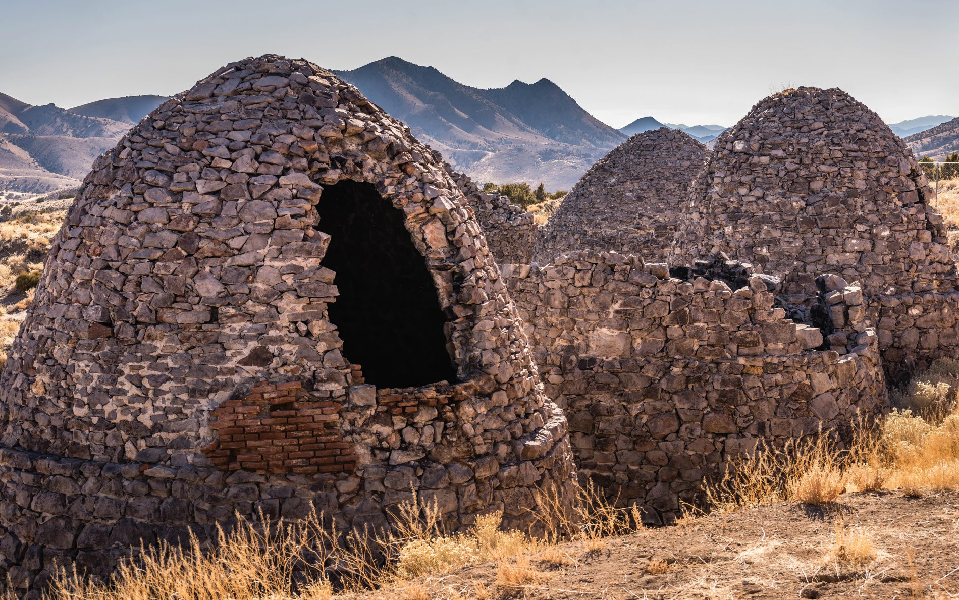
1. The Old West Lives at Frisco Ghost Town
Rip-roaring Frisco, sitting on the edge of the San Francisco Mountains, was reputedly Utah’s wildest town during its 1880s mining heyday. Miners, fueled by 23 saloons, made Frisco the murder capital of the Old West with almost daily shootouts on its dusty streets. One writer described it as “Dodge City, Tombstone, Sodom and Gomorrah, all rolled into one.” Between 1879 and 1929, area mines yielded fortunes in silver, gold, zinc, lead, and copper that were hauled away on the Utah Southern Railroad.
Fortunes changed in 1885 when tunnels in the Horn Silver Mine, the world’s richest silver mine, collapsed and miners began leaving. Now Frisco, inhabited by mice and owls, is a windswept collection of tattered wooden cabins and buildings, along with five beehive-shaped charcoal kilns used to make coke for a smelter. Nearby is boot hill, the town cemetery filled with graves haunted by men killed in mines and by a six-shooter. Visit the ghost town by driving 15 miles northwest on the Ely Highway from Milford.
2. Driving the Beaver Canyon Scenic Byway
One of central Utah’s best scenic drives is the Beaver Canyon Scenic Byway, which follows Utah Highway 153 up a spectacular canyon for 17 miles from Beaver to Eagle Point Ski Resort on the western edge of the wild Tushar Mountains. The narrow paved highway twists alongside rushing Beaver River, gaining 3,700 feet as it passes campgrounds, picnic areas, trailheads, and fishing holes. The byway passes Eagle Point Resort—a ski area with 650 skiable acres, 40 trails, a terrain park, and more than 350 inches of powder snow—and climbs a final mile to Puffer Lake and the end of the byway and paved road. Look for side roads that lead to high lakes, including Kent Lake, Little Reservoir, and the lovely Three Creeks Reservoir. Another side trip follows Forest Road 123, the Kimberly/Big John Scenic Backway. This dirt road runs 22 miles over the Tushars, passing 12,169-foot Delano Peak, Beaver County’s high point, before dropping into Piute County and mine ruins at Lower Kimberly.
3. Trout Fishing at Minersville Lake Recreation Area
Minersville Reservoir, the largest lake in Beaver County, is one of the best places near Beaver to cast a fishing line and reel in an 18-inch rainbow trout. The lake, covering 990 acres when full, nestles against the southern edge of the Mineral Mountains. As water temperatures warm during the summer, the lunker trout retreat to the cold depths so you’ll find more success angling from a boat, except in evening or morning when they surface near the shore. Smallmouth bass and wiper are also caught. Fisherman can only use artificial flies and lures and bait fishing is prohibited. A Beaver County campground with restrooms, showers, non motorized water rentals and paved boat ramp are on the south shore, although most of the shoreline lies on BLM public land.
4. Off-Road Adventure on the Paiute ATV Trail and other great ATV Trails
The Paiute ATV Trail, one of the best ATV trail systems in the United States, twists through four counties in central Utah, including Beaver County. The trail includes a 275-mile loop and over 2,500 miles of side trails and forest roads through Fishlake National Forest and on Bureau of Land Management public lands. The Beaver Side Trail, a 72-mile loop that begins and ends in Beaver, is a fabulous ATV trip that follows rough tracks and dirt roads up canyons, over high ridges, and through dense forests and open meadows. While expert riders travel the route in a day, it’s fun to pack a tent and sleeping bag and camp along the way. Check at the Fishlake National Forest ranger station in Beaver for maps and trail information.
5. Exploring the Mineral Mountains
The Soldier Pass Trail, a dirt road easily driven by two-wheel-drive vehicles, climbs over 7,388-foot Soldier Pass in the wild Mineral Mountains west of Beaver. The Minerals, a rough range with steep mountains and gleaming white granite domes, is one of Utah’s best rockhounding areas. Collectors search the range for opal, smoky quartz, pyrite, azurite, obsidian, gold, silver, and highly prized blue beryl, one of the world’s rarest gemstones. If you park right at the top of the pass there is a fence line, follow the trail on the east side of the fence to discover and secret hidden pool. This pool of water is surrounded by jagged rock formations. Although not suited for swimming, it is a fascinating place to explore. The 28-mile-long range is also home to the Lincoln Mine, Utah’s first documented mine, which yielded silver and lead in 1858. The Rock Corral Recreation Site on the west side of the Mineral Mountains offers trails, climbing routes, campsites, and a picnic area. Start the steering wheel adventure in Milford and head southeast into the mountains. Be sure to stop on the pass summit for stunning views west to the Wah Wah Mountains and Escalante Desert, east to the towering Tushar Mountains, and north to craggy Granite Peak, the range high point.
Written by Stewart Green for RootsRated in partnership with Utah Office of Tourism and legally licensed through the Matcha publisher network. Please direct all licensing questions to legal@getmatcha.com.
Featured image provided by Adam Haydock
Ramble Responsibly Ramble Responsibly
Explore with care in Beaver County


